
Almost two months into winter and still only trivial snow is in the forecast. Without the first inch of snow accumulation just yet, some D.C.-area residents may be wondering what is causing this pattern shift.
Blame it on La Nina.
The National Weather Service said a La Nina refers to “persistent colder-than-normal (0.5°C or greater) sea surface temperature (SST) anomalies across the central and eastern equatorial Pacific.”
La Nina is historically not favorable for snowfall in the D.C. region. The cooling of the equatorial Pacific shifts jet stream patterns across the globe and typically enhances the Pacific jet stream. This punishes the West with wintry weather but floods much of the country with warmer temperatures.
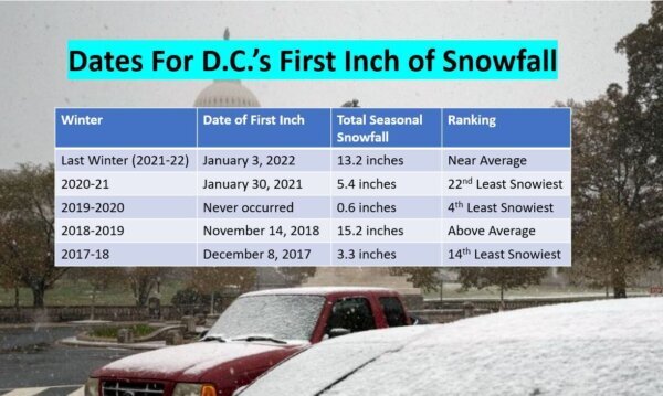
This year is the third La Nina winter in a row in the D.C. region. An early January snow last year helped push snowfall totals in the second of three consecutive winters to 13.2 inches, which is still shy of D.C.’s annual average of 13.7 inches.
The first in our three consecutive La Nina winters in 2020-21 only produced 5.4 inches of snow for the season.
A notorious high pressure ridge sitting off the Southeast coast during La Nina winters sends the storm track west of the D.C. area. This allows a milder southeast wind flow ahead of Pacific storms, allowing precipitation to be rain instead of snow.
The only La Nina winter that sticks out like a sore thumb is 1995-96 winter, which produced the historic Blizzard of 1996. D.C. ended up with 46 inches of snow, which tied as the second largest seasonal snowfall in the nation’s capital.
When looking at data from the past five winters, the first inch of snow is trending later in the season. In recent years, especially during the recent La Nina winters, it has been occurring in January.
Looking ahead, Wednesday offers the only chance for snow to kick off the next system. But the first inch of snow will not fall before precipitation changes to rain.
Thereafter, the La Nina influence will keep D.C. on the soggy side rather than the snowy side of weather systems going into the first half of February.